(Photograph © J. G. Coleman)
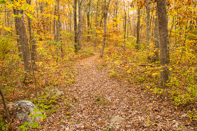
At more than 60 acres, Finch Brook Preserve is one of the Wolcott Land Conservation Trust’s largest properties, offering a well-blazed trail that meanders through the picturesque wooded hills of southwestern Wolcott. The bulk of the preserve was donated to the Wolcott Land Conservation Trust in 1997 and a subsequent land donation in 2012 helped to enlarge the property even further.
Hiking
Finch Brook Preserve features a blue-blazed loop trail of roughly 2.5 miles† that winds through scenic woodlands in the vicinity of Finch Brook. In fact, in May 2014 the trail was admitted into the official Blue-blazed Hiking Trail System organized by the Connecticut Forest & Park Association. The length of this hike ensures that visitors to the preserve can truly immerse themselves in the peaceful woodland atmosphere. We invite you to visit anytime between sunrise and sunset and enjoy this special expanse of hilly wildlands.
Accessing the preserve is simple: just head to the end of Barbara Drive in Wolcott. Park along the outer edge of the cul de sac and enjoy your hike! As always, please be sure to take only photographs and leave only footprints.
Be sure to download a trail map of Finch Brook Preserve for your next hike. Two versions are available: one produced by us here at WLCT and one produced by the Connecticut Forest & Park Association. Both are excellent ways to navigate the trail.
- Download the trail map created by WLCT
- Download the trail map created by the Connecticut Forest & Park Association
† The length of the trail at Finch Brook Preserve may change occasionally. See our trail map for the latest information.
History
A map of Wolcott drawn up in the years immediately following the Civil War shows the area of WLCT’s Finch Brook Preserve as a conspicuous blank in the “South District” of Wolcott, devoid of any mills or residences. About a half mile northeast of the modern-day preserve lived one “R. Finch”, after whom Finch Brook was perhaps named. Roughly a third of a mile east lived members of the Upson and Todd families. But although the map shows no indication of human presence in the immediate boundaries of Finch Brook Preserve during the late 1860s, it’s unlikely that the land had avoided human influence. As was the case with much of Connecticut in that era, the land had probably been clear-cut for timber at some point in the early half of the 1800s and may have subsequently found use as pastureland. Successive hand-drawn maps released through the 1890s continue to show a lack of residences, farms or other enterprises in the modern preserve boundaries. Even though a sawmill existed at one time on the banks of nearby Lily Brook, which is of similar size, it seems that Finch Brook lacked the reliable waterpower to attract any industry in Wolcott’s earlier days.
We get our first good look at the property in 1934, when aerial photography of the entire state was conducted. The imagery shows that the lands of Finch Brook Preserve were thickly reforested eight decades ago, indicating that the woodlands there are easily a century or more old.
USGS maps from the 1940s, 1950s and 1960s offer a tell-tale clue as to why Finch Brook Preserve seemed to have avoided any major settlements for so long. Much of the property surrounding Finch Brook is illustrated as swamplands, which would have made the property unsuitable for most forms of development. Although there are certainly still wetland areas in the preserve today, many are skillfully dodged by the WLCTs blue-blazed trail, which tends towards the elevated areas of the landscape.
(Photograph © J. G. Coleman)
Geography, Environment and Habitat
Finch Brook
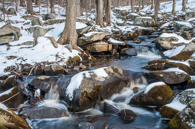
Finch Brook, the namesake feature of the preserve, is a small stream that flows a quarter-mile through the center of the property. Rising in the far-south of the town near the Waterbury line, it courses more than a mile northwards, joining with Lily Brook before the combined waters of both streams empty into the Mad River.
Although it is among the more modest brooks of Wolcott, Finch Brook possesses a large enough watershed that it can typically maintain flow year-round. Consequently, it offers local wildlife a reliable watersource and feeds wetlands in the center of the preserve that are surely home to a variety of snakes and amphibians.
We are always interested to hear about any wildlife you observe while hiking at Finch Brook Preserve.
(Photograph © J. G. Coleman)
Woodlands
The bulk of the woodlands at Finch Brook Preserve are generally classified as Oak-Hickory Forest, meaning that they are dominated by oak species and interspersed with hickory, maple and birch. Prior to the late 1800s, chestnut trees were probably a common species as well, but that would have begun to change around the turn of the century. Chestnut blight fungus was accidentally imported to the US from Asia in the late 1800s and it quickly took a devastating toll upon forests of the northeast. In only a handful of decades, literally millions of Connecticut chestnut trees succumbed to the fungus. A tree species which had once comprised as much as 25% to 50% of the forest canopy had been almost entirely eradicated from the landscape. Every sizable specimen throughout state’s forests had died off, including those at Finch Brook Preserve.
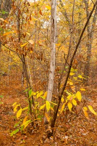
But even though chestnut trees were decimated by the blight, they were not entirely driven to extinction. Evidence of this can be found in areas of Finch Brook Preserve where small, shrub-like chestnut trees continue to struggle against the blight fungus (see photo at right). These persistent survivors are sometimes called “living stumps”, because they exist only by virtue of the fact that the roots of the chestnut are resistant to the blight. So even though the larger trees have long perished, their remaining roots continue to send up new saplings. These fresh trunks rarely last very long before they die back, at which point new saplings shoot up from the same rootstock. Living chestnut stumps have persisted this way for several decades, forever sending up new trunks, but unable to grow any of them to maturity. Without the ability to re-seed the surrounding forest, surviving chestnut trees such as those at Finch Brook Preserve are unique “genetic islands”… isolated pockets of the chestnut gene pool that have managed to survive into the 21st century against all odds.