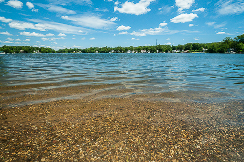
(Photograph © J. G. Coleman)
At well over 100 acres of open water, the combined area of the northern and southern halves of Hitchcock Lake comprise the largest property owned by the Wolcott Land Conservation Trust. When the lakes came under the ownership of the WLCT in 1986, they were officially the first property we acquired. Our stake in these lakes was later expanded in 1992 when we received an additional parcel of lakeside land associated with the dam.
Management & Recreation
The majority of the shoreline surrounding the Hitchcock Lakes is privately-owned and the WLCT leases the lakes to the Hitchcock Lake Improvement Association for use by its members. For these reasons, public visitation of the Hitchcock Lakes is permitted only at the town-operated Mattatuck Beach.
Members of the Hitchcock Lake Improvement Association are welcome to enjoy themselves in compliance with the rules and regulations set forth by the Wolcott Land Conservation Trust.
You can feel free to download the WLCT’s Rules & Regulations for Hitchcock Lake.
History
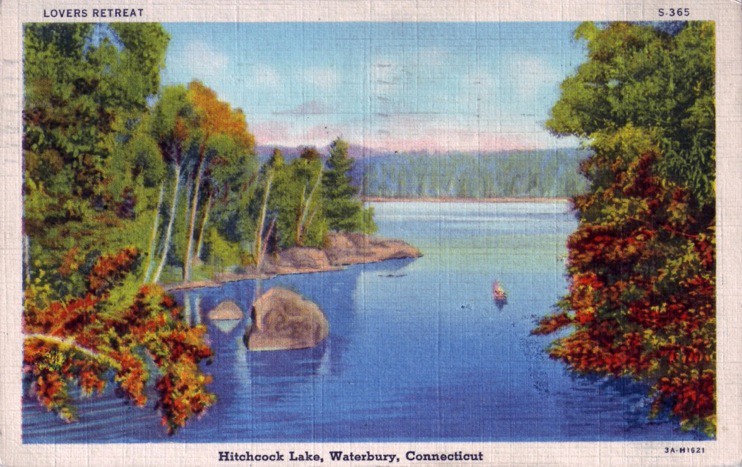
The rise in popularity of Hitchcock Lake during the earlier half of the 20th-century was described by Wolcott historian, Florence Goodman, in her September 2009 article:
Around 1913, the Waterbury and Milldale Tramway Company, also known as “The Green Line,” trolley began to provide service from the center of Waterbury to southern Wolcott along Meriden Road to Hitchcock Lake. This area, known as Shelt’s, received its name from Mr. Shelton Hitchcock, whose home was located on Meriden Road near the head of the lakes.
The land surrounding the lakes became a favorite retreat for city people. The pure spring water and peaceful scenery made it a popular water resort and this new transportation caused a rapid development of these twin lakes. As the Lake area continued to develop, the small summer cottages were converted into year-round homes and by the early 1940s, the land along the shores had emerged as one of Wolcott’s principal suburban residential neighborhoods.
Aerial photography of Hitchcock Lake produced in 1934 certainly confirms that the lakefront was already becoming a popular place for homes and cottages, even if there were still long stretches of shoreline that remained undeveloped.
When the US Geologic Survey released its topographic maps of Wolcott in 1946, the name “Waterbury Reservoir” was gone, finally replaced by the name “Hitchcock Lake” that has stuck to this day.
Geography, Environment and Habitat
Hitchcock Lake Brook
The waters of Hitchcock Lake are supplied by springs and run-off, so while there is no distinct stream that feeds the lake, there is a small outlet stream known as Hitchcock Lake Brook. By following the path of this brook after it departs from Hitchcock Lake, we can learn of the unique interconnectedness of some of our WLCT preserves and get a broader idea of the impact that we all have upon Connecticut’s major water resources.
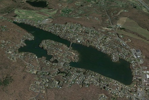
(Satellite Map Courtesy of Google via Google Earth)
We can understand the importance of these connections even more deeply if we continue to follow the waters from our open spaces once they’ve joined the Mad River. After flowing for another few miles through Waterbury, the Mad River eventually empties into the much larger Naugatuck River which courses some 15 miles south before it, in turn, empties into the Housatonic River. Finally, after ten more miles of southward travel, the Housatonic River terminates at Long Island Sound, continually dumping tens of thousands of gallons of freshwater into the ocean. Among the vastness of the Housatonic are the waters that wash down from Wolcott, out of Hitchcock Lake or through Finch Brook Preserve. So although it is true that Hitchcock Lake and Finch Brook are distant from the seashore, keeping their waters clean can help to improve some 30 miles of streams and rivers and, ultimately, Connecticut’s precious piece of the Atlantic Ocean.